Santiago 1522 - 2016
 |
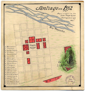
| Map of Santiago de Chile 1552 showingthe Mapocho River and the historic centre. |
 |
| Base Plan for an urban design competition for Explanda de los Mercados 2015 showing the canalized Mapocho River |
In 2015, a public competition called Explanada de los Mercados (the market esplanade) was announced to redesign the area that spanned both sides of the Mapocho River in central Santiago. This is the area where the canalised Mapocho has it's worst contemporary reputation as a place of disease, death and dirt. The competition was to create a design solution that would connect both sides of the Mapocho River and generate a type of culinary tourist precinct. The site included the fish and produce markets, a heritage walk of iconic colonial churches, the former train station now exhibition space Estacion Mapocho, a major metro station, bus interchange and collecive taxi terminal. Another interesting aspect of this competition was that it was obligatory to use the remains of the Cal i Canto Bridge as a public artwork within the site. In the winning design this did not eventuate. The Cal i Canto bridge formerly connect both sides of the Mapocho and was destroyed by flooding, in what some describe as suspicious circumstances when the river was being canalised. The site holds four bridges, including the closed pedestrian bridge Puente los Carros and generous public spaces and parks. It borders the municalities of Santiago, and the poorer migrant areas of Recoleta and Independencia.
The idea of the proposition Santiago 1552-2016 was to map the original course of the Mapocho and to hypothetically re-impose this on the site. A drawing that represented the Mapohoco River, taken from a 1552 map, was simply cut from the map and placed at scale onto the CAD map of the design competition site as a collage. The idea of taking a drawn representation of a torrent that changes its form is an absurd way to indicate the precision with which the CAD drawing represents the site but at the same time the idea of layers within a CAD drawing affords the idea of an episodic river being able to be re-represented. The two drawings combined as a relief emphasises this point. As a thinking exercise, collage allows a way to represent at least two realities simultaneously. In the gallery, the map of the original Mapocho is cut out of the CAD drawing, that is mounted on foam core board, and the river itself is painted onto the wall. 5mm below. This 5mm represents a scaled version of the canal at 1:1000 i.e. 5 metres. With an overhead projector, visitors to the gallery can speculate about how to cross the original course of the Mapocho using the contemporary map. The 1552 map is prior to the Cal i Canto bridge and the canalisation. Visitors were asked to draw their connections across central Santiago and place them in the Ideas Box (Buzon de Ideas). The difficulty of drawing onto the map from an overhead is that the actions are in inverted.
 |
| Collage of the original course of the Mapocho River 1522 overlaying the canalised course of the contemporary city of Santiago 2015. |


Comments
Post a Comment