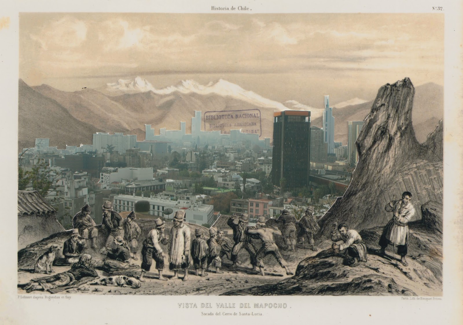
Vista del Valle del Mapocho. Sacada del Cerro Santa Lucía.1843-2016


There are five images that share the same view of the Mapocho Valley looking eastward towards the Cordillera from Cerro Santa Lucía - the hill made into a vertically spiralling public park by Benjamín Vicuña Mackenna in the late 19th Century. Cerro Santa Lucía has become one of the four icons of Santiago in landscape painting of the late 19th and early 20th centuries.
The created image here is a collage of a reproduction of the lithograph created from drawings by M. Rugendas and C. Gay and printed by F.H. Lehnert for the Atlas of the Physical and Political History of Chile in 1854 and a photograph taken by me from the same point of view in 2016. The Atlas was produced in two version, one in black and white and the second in colour. In my photograph, you can no longer see the path of the Mapocho River but you can see two built icons that have replaced it - the brown building in the mid ground is Diego Portales that forms part of the San Borja housing development of the 1960s, is part of the famous GAM, National Cultural Centre of Gabriela Mistral, and was the headquarters of the Military Dictatorship immediately after the coup and the bombing of la Moneda in 1973. In the framed collage (below) featured the exhibition Orillas, Puentes y el Torrente, you can also see in the distance the Costanera Centre, the tallest building in Latin America and the new centre of Santiago in what is known as SanHattan (Santiago Manhattan) and is located on the edge of the Mapocho River where it converges with Canal San Carlos. In this sense it is the landmark for where the Mapocho becomes the urban torrent as it enters the canalised section of its course. What you also see in the foreground of the lithograph in this collage is a composite of scenes that Rugendas took from different parts of early 19thC contemporary Chilean society - the geologists, the urbanized campesinos with traditional clothing, the street dogs and, curiously, a fight in the middle foreground of the composition. The other notable element is the large rock on the right hand side that cannot be seen from the same position in Cerro Santa Lucía as the original image was created when this was cerro Huelén prior to its conversion into the public park in the mid 19thC. The collage is a combination of the black and white version of the drawing and a colour photograph. A Kodak color scale is part of the framed work referring to the restoration and archival process of the collection that holds the original Atlas from which the copy is taken. In this copy you will note the stamp of the national library behind the Costanera Centre.
The other four images created from this same view include, in chronological order: Vista de Santiago desde el cerro Santa Lucía (1843) by M Rugendas (a painting) as the basis of the lithograph in the Atlas; an illustration entitled Santiago Vista general del Cerro Santa Lucía (1872) by R Tornero that was printed in Chile Illustrated; one of the most famous images of Chilean landscape/historical painting La Fundación de Santiago in 1551 (The Foundation of Santiago in 1551) by Pedro Lira (1889) which curiously features the same rock though it was painted after Cerro Santa Lucía was created and historically located in reference to the image by Rugendas; and Santiago desde el Santa Lucía (1911) by Thomas, J Somerscales, a quasi impressionistic image of the same valley.
 |
| La Fundación de Santiago en 1551. Pedro Lira (1889) |


Comments
Post a Comment